

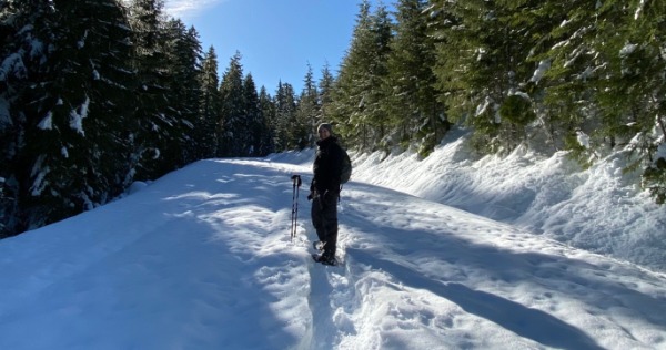
Snowshoeing in the Cascade Range
The Willamette Valley sits between two mountain ranges—including, at our eastern edge, the Cascade Range. It's there, from the Cascade foothills to the crest of the dramatic mountain range, that snowshoers find plenty of fresh powder, old-growth forests, and wide-open vistas all winter long.
If you're planning an epic snowshoeing adventure, we've put together a guide to the top trails in the Cascades, along with helpful directions from some of the Willamette Valley's most popular communities. So after you've picked up rentals from your favorite local retailer—such as Berg's Ski & Snowboard Shop in Eugene and Peak Sports in Corvallis—keep reading for tips, recommendations, resources and more for enjoying a fun snowshoe outing this winter.
Getting to the Cascades
Four major highways head between the Willamette Valley and the heart of the Cascades. From north to south, here's the skinny on each:

Highway 22 (Salem, Detroit, and Breitenbush Hot Springs)
Highway 22 departs from Salem and heads east through the communities of Mill City and Detroit.
Highway 20 (Albany and Santiam Pass)
Highway 20 passes through Philomath, Corvallis, and Albany before ascending toward Santiam Pass.

Highway 126 (Eugene and McKenzie River)
Highway 126 leaves Eugene and Springfield before following the McKenzie River through McKenzie Bridge and Belknap Springs.
Highway 58 (Eugene and Oakridge/Westfir)
Highway 58 leaves Eugene and heads southeast through the likes of Oakridge and Westfir.
Snowshoeing Around Detroit and Detroit Lake

Highway 22 heads east from Salem and passes through the community of Detroit—which sits on the shores of Detroit Lake and in the Cascade Range foothills. The community makes an idyllic jumping-off point for snowy adventures in the surrounding forests. Before visiting, contact the Detroit Ranger District for updated trail conditions and other helpful information.
Top Trails and Sno-Parks: Maxwell Sno-Park hosts 25 miles of trails for outdoor enthusiasts of all fitness and skill levels; several trails pass the park's Mountain View Shelter, which on a clear day affords views of Three Fingered Jacket, Mount Washington, and other peaks. Consult a Maxwell Sno-Park trail map to understand the sprawling network of paths before heading out.
Post-adventure fun: Detroit sits near the midway point of the 220-mile West Cascades Scenic Byway, which runs north-south along the western edge of the Cascade Range; highlights along the scenic drive include crystal-clear mountain rivers and views of snow-covered volcanic peaks.
Overnight stays: Detroit Lake State Recreation Area hosts nine cozy cabins on the shore of Detroit Lake, all open October-April, that sleep up to three and include a heater; running water and hot showers are available at the campground, as well. Nearby, Breitenbush Hot Springs hosts cozy overnight stays and several clothing-optional hot springs pools in the midst of a lush forest; the popular resort is one of several hot springs in the Willamette Valley.

Photo by Matt Cook
Snowshoeing on Santiam Pass

Take Highway 20 east from the likes of Corvallis and Albany, and it's a scenic 90-minute drive to Santiam Pass and the Middle Santiam Wilderness. Here, snowshoers can choose among nearly a dozen Sno-Parks near the crest of the Cascades. Before heading out, contact the Sweet Home Ranger District or the McKenzie River Ranger District for conditions at your preferred Sno-Park(s).
Top Trails and Sno-Parks: From the Tombstone Sno-Park, the Tombstone-Prairie Connection parallels Highway 20 while following a snowy forest road; occasional peak views rise above the quiet forest. For a more challenging trip, Potato Hill Sno-Park hosts a few steep, yet rewarding trails that offer views of Lost Lake, Mount Jefferson, and other snowy summits.
Post-adventure fun: On your way back to the Willamette Valley, fuel up with sandwiches, pasta, seafood, and other hearty dishes at The Point Restaurant and Lounge in Sweet Home. Also in Sweet Home is Casa de Reyes, which serves flautas, burritos, and other filling Mexican dishes.
Overnight stays: Enjoy a night along the South Santiam River at River Bend County Park, which hosts heated cabins and yurts with on-site restroom facilities. Other overnight stays along Highway 20 include Foster Lake Inn & Vacation Lodge (housed in a 1940s-era historical home) and Foster Lake RV Resort (which offers four log cabins and a pair of western-themed studio rooms).

Snowshoeing in the McKenzie River Region

Highway 126 heads east from the Eugene and Springfield area, largely following the azure McKenzie River as it ascends into the heart of the Cascades; there, the road ends at Highway 20 near Santiam Pass. The communities of Rainbow and McKenzie Bridge make excellent bases for winter fun higher in the mountains. Before starting your trip, contact the McKenzie River Ranger District for updated conditions, recommendations, and more.
Top Trails and Sno-Parks: Ikenick Sno-Park provides access to a mix of easy and moderate trails that showcase the best of the region—including views of Three Fingered Jack, Mount Washington, and plenty of second-growth forest.
Post-adventure fun: Stop by Clear Lake, which lives up to its name with a shimmering, bright blue hue—never more apparent than on sun-kissed afternoons; views are enchanting from the day-use area, and a 5.3-mile hiking trail circles the lake. If you're itching to see more of our hot springs, enjoy a soak at Terwilliger (Cougar) Hot Springs—a clothing-optional series of pools that can be reached via quarter-mile trail in a lush forest.
Overnight stays: Enjoy a soak in one of two mineral hot spring pools (and an overnight stay in lodge rooms and cabins) at Belknap Hot Springs. Nearby, the forested Horse Creek Lodge hosts four family-friendly cabins that include in-room fireplaces, kitchenettes, and comfortable amenities. Learn more about mountain getaways in the Cascade Range.

Snowshoeing Around Westfir and Oakridge

Highway 58 heads southeast from Eugene, passing the communities of Oakridge and Westfir (both mountain biking hotspots in summer) on its way into the heart of the Cascade Range. Get recommendations for where to go, trail conditions, closure updates, and more by contacting the Middle Fork Ranger District.
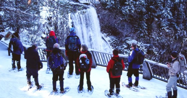
Top Trails and Sno-Parks: Salt Creek Sno-Park sits surrounded by a network of trails and affords views of Salt Creek Falls; the thundering cascade drops 286 feet and is the second-tallest waterfall in Oregon. Families can also go sledding and tubing on a well-maintained play area within the Sno-Park, as well.
Post-adventure fun: Warm up with a relaxing soak at nearby McCredie Hot Springs, a clothing-optional spot that can be accessed via a mostly flat, half-mile (one-way) hike; the pools are adjacent to Salt Creek and are two feet deep; consider bringing a thermometer to ensure the water is not too hot before easing into the pool.
For more outdoor inspiration, check out our guide to hikes, soaks, and other winter adventures around Westfir and Oakridge.
Overnight stays: Enjoy a comfortable overnight stay at Westfir Lodge & Mountain Market—which sits in the heart of its namesake community and across the street from the historic Office Covered Bridge.


General Tips for Your Snowshoeing Trip
Weather is unpredictable in the mountains, so be sure you have a capable 4WD or AWD vehicle with enough clearance to pass snow ruts in the roads. You can check road conditions, webcams, and traffic alerts on the main highways at the Oregon Department of Transportation's TripCheck.
Also note that Forest Service roads are not typically plowed in winter.
- Start by reading the Willamette National Forest's Winter Safety webpage, which includes tips for what to pack, planning ahead, and even how to limber up before your excursion.
- Bring more food and water than you think you'll need in the event you get stuck or are out snowshoeing longer than planned.
- Dress wisely, and wear layers, based on conditions. Check out REI's guide to layering basics so you're prepared with the right gear to stay warm.
- Snowshoeing is tougher than hiking, especially in untracked snow, so only do as much as your individual and group fitness allows. Leave enough energy to return to the trailhead.
- Either download an area map or bring a paper copy as cell service is non-existent outside small communities in the Cascade Range and over mountain passes.
- Before heading out, check the Willamette National Forest's "alerts" page to ensure your preferred trail is open and accessible.